


Who We Are
Guide of the Year
Documents
Charity & SR
Latest Posts
Questions & Answers

Standing as the highest peak of the Langtang Himalaya subrange, Langtang Lirung is one of Langtang National Park’s most prominent features. Drawing trekkers from far and wide, this majestic mountain is especially known for its sharp vertical ascent that rises 18,000 feet above sea level.
Langtang National Park is the fourth protected area in Nepal – and for good reason.
Not only does it offer a blend of ice, snow, and rock climbing, but this mountain is ideal for both experienced and rookie trekkers alike. Indeed, the ascent features a fairly slow and steady pace that allows for a gradual acclimatization to the high altitudes.
From the summit of Langtang Lirung Nepal, you’ll be treated to 360-degree views of Langtang Valley, the glaciers, and all the surrounding peaks.
One of the best things about this mountain is that it can be done in a single trek or in combination with more challenging trails like the Annapurna Circuit trek or even the Everest Base Camp trek.
Key Summary Table: Langtang Lirung
Particulars | Details |
Location | Langtang Himal, Nepal-Tibet border |
Highest Peak | Langtang Lirung (7,234 m approx.) |
First Successful Ascent | 1978, Pemba Tsering Sherpa & Seishi Wada |
Trekking Route | Kathmandu → Syabrubesi → Lama Hotel → Langtang Village → Kyanjin Gompa → Glacier → Base Camp |
Flora | Rhododendron, Oak, Pine, Bamboo, Nepalese larch |
Fauna | Red Panda, Himalayan Thar, Snow Leopard, Musk Deer, Himalayan Brown Bear |
Accommodation | Tea houses along the trail |
Permits | TIMS Card ($8-15), National Park Entry ($30) |
Risk Factors | Avalanches, landslides, high-altitude sickness, earthquakes |
Best Time to Trek | Spring (Mar-May), Autumn (Sep-Nov) |
Designed as a ‘trekking peak’ by the Nepal Mountaineering Association, the mountain stands as an imposing structure along the Langtang Circuit Trek. Lying on the Tibetan border, the mountain’s imposing south face is even visible from popular routes like the Langtang Valley trek and Kyanjin Gompa.
Part of the Langtang Himal subrange, Langtang Lirung is bordered by the Trisuli Gandaki Valley to the west and the Sun Kosi Valley to the east.
Well, located at a latitude of approximately 28º 15′ 22 and a longitude of 85º 31′ 10, it lies right on the border line between Nepal and Tibet, just north of Kathmandu.
The Langtang Himal subrange is made up of fourteen peaks, but Langtang Lirung’s height easily towers over the other peaks – and that’s saying something, given that the other peaks are all exceptionally tall as well.
Langtang Lirung Himalaya has a rough topography that comprises of throughs, ridges, local debris mounds, and depressions. The Langtang region is a famed destination for trekkers, mostly because the local ecosystem is all interconnected.
In fact, Langtang Lirung has a significant relationship with the Langtang Lirung Glacier, mainly because the mountain serves as the main source of snow and ice for the glacier.
As snow accumulates on Langtang Lirung, it eventually morphs into glacial ice that feeds the Langtang glacier, eventually making its way down the valley. This not only contributes to the area’s hydrology but also helps in shaping the landscape.
Now that we’ve covered where Langtang Lirung is, let’s take a look at the (many) amazing vistas that await at the top.
Indeed, at the summit of Langtang Lirung Nepal, you’ll have the best seat in the house for soaking in incredible views of the Langtang Glacier and nearby peaks. These include Ganesh Himal, Langshisa Ri, and the popular Dorje Lakpa, which towers at nearly 7,000 meters.
Offering an incredible backdrop to the Langtang Valley, Dorje Lakpa is easily recognizable by its pyramid-like shape. Visible from Kathmandu Valley, this impressive peak offers various trekking routes with varying degrees of difficulty.
The region is additionally home to the Langtang Lirung Naya Kanga peak which stands at 5.846 meters. Also known as Ganja La Chuli, this mountain is notoriously hard to climb and requires excellent physical fitness.
The mountain range also offers easy access to other adventures like the popular Yala Peak climbing expedition.
Peak | Height (m) | Notable Features |
Ganesh Himal | Varies | Prominent Langtang peak |
Langshisa Ri | Varies | Remote and scenic |
Dorje Lakpa | ~7,000 | Pyramid-shaped, visible from Kathmandu, trekking routes of varying difficulty |
Langtang Lirung Naya Kanga (Ganja La Chuli) | 5,846 | Challenging climb, requires excellent fitness |
Yala Peak | Varies | Popular climbing expedition |
The mountain was first discovered in 1949. In the 1960s, numerous attempts were made to summit the peak through the East Ridge, but the efforts were in vain.
It wasn’t until 1978 that Pemba Tsering Sherpa and Seishi Wada were finally able to summit Langtang Lirung through the East Ridge.
Early climbing attempts were notoriously marked by bad weather and technical issues. An initial reconnaissance was made by Peter Lloyd and Bill Tilman in 1949.
When the first British climbers initially tried to reach the top via the Langtang Lirung South Face, they realized that this flank was marred by a vast cirque.
After a failed attempt to summit Langtang Lirung Nepal, Tilman, accompanied by Tenzing Sherpa, planned an expedition up the Lirung Glacier, but they couldn’t make it past the subsidiary ridge.
Not wanting to give up, Tilman then attempted another summit through the north face of Langtang Lirung which runs along the Tibetan border. This was another failed attempt as the mountaineers got lost, eventually ending up in Tibet.
This climbing attempt was soon followed by a second failed summit push in 1959 by Tetsuo Yamada and his Japanese party. They tried to approach from the southeast side, but they were unable to find a feasible trail leading to the surface.
So, they changed their route, becoming the first team to successfully scale Phrul Rangtshan Ri mountain, a 6,707-meter peak located east of the mountain.
The first successful expedition didn’t occur until 1978, forever changing the mountain’s climbing history.
Langtang Lirung is now said to be among the best mountains for amateur trekkers, but that doesn’t mean that it’s devoid of dangers. While the mountain no doubt offers panoramic views and a sense of accomplishment, it’s crucial to remain vigilant and navigate the treacherous terrain with slow and measured footsteps.
Mountaineering risks exist at the southeast or southwest ridge, no matter how easy the climb is. In fact, the death toll includes notable climbers like Cesare Volante and Giorgio Rossi who were swept away by a sudden avalanche in 1963. Two years ago, the mountain was hit by another avalanche that killed a sherpa and two Japanese mountaineers.
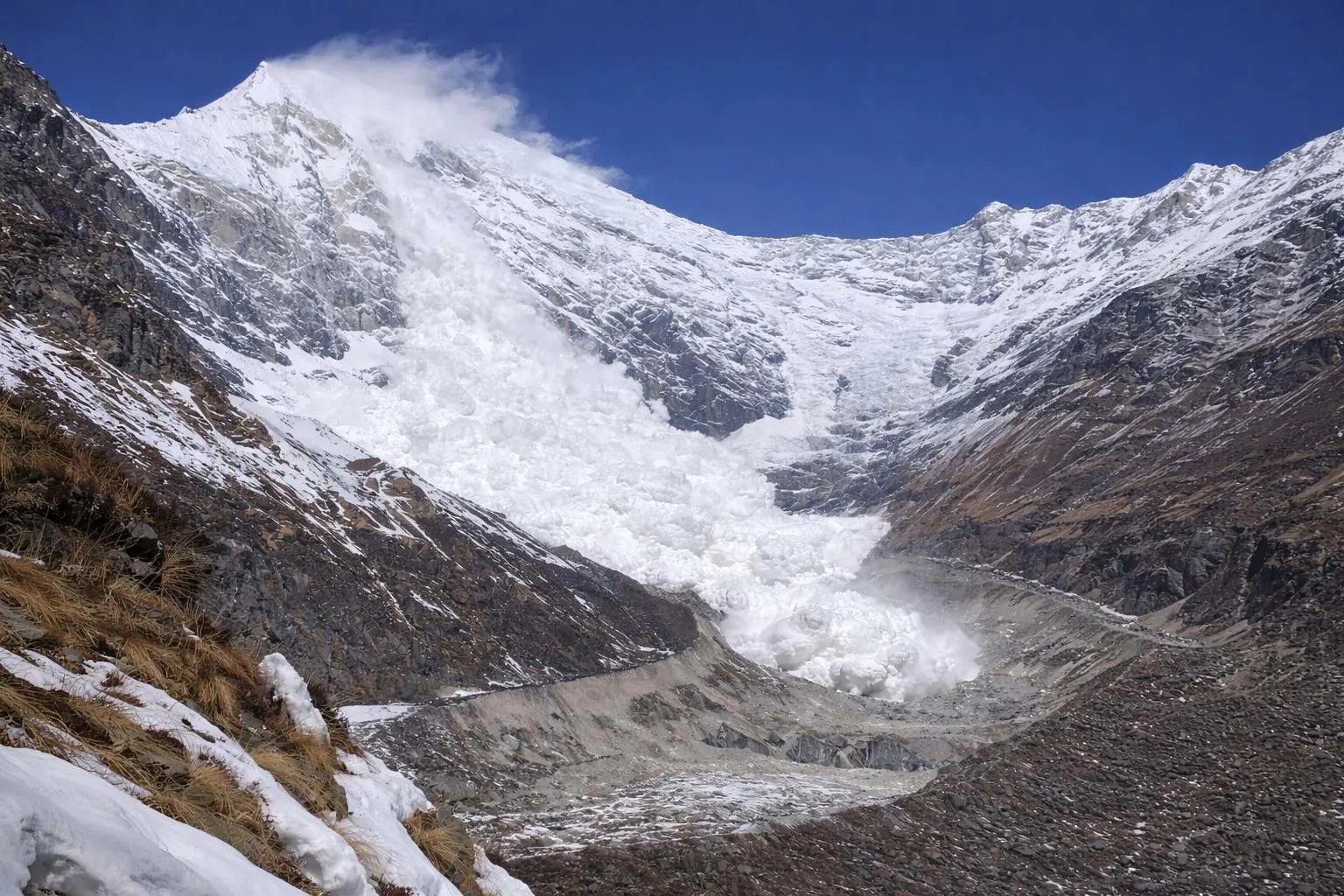
In 2009, another avalanche would claim the life of Thomaz Humar in a tragic incident that would become known as the ‘Langtang Lirung Humar’ tragedy.
More recently, the earthquake of 2015 sent shockwaves across the country, killing hundreds of locals and foreigners alike. The 7.8 magnitude quake sent a landslide on the mountain, completely obliterating Langtang Village.
Langtang village before and after couldn’t be more different. It took the survivors years to rebuild their village and the trekking route around the mountain wasn’t declared safe until 2018.
The disaster claimed the lives of 80 foreigners, 10 members of the Nepalese army, and 176 Langtang residents. Out of the casualties, 100 bodies were never found and are presumed dead.
The mountain’s climbing history is riddled with failed summit attempts as well as tragedies. It’s not all gloom and doom, though: the mountain has seen plenty of victories, with the main successful expedition led by Pemba Tsering Sherpa nearly 46 years ago.
The first successful Langtang trek comprised three sherpas as well as members of an Osaka City University team. The group targeted the east ridge of Langtang Lirung, approaching the mountain through the Langtang glacier.
The party reached Camp 2 (5,710 meters) on October 15, Camp 3 (6,280 meters) on October 19, and Camp 4 (6,800 meters) on October 22. Finally, on October 24, Pemba Tsering Sherpa and Seishi Wada were the first people to successfully scale the mountain.
Pemba Tsering Sherpa and Seishi Wada eventually paved the way for other famous climbers who would eventually explore the rocky slopes.
While suitable for amateur trekkers, Langtang Lirung carries risks:
Year | Incident | Details |
1963 | Avalanche | Cesare Volante & Giorgio Rossi killed |
2009 | Avalanche | Thomaz Humar killed |
2015 | Earthquake & Landslide | Langtang Village destroyed, 80 foreigners, 10 Nepalese army, 176 locals killed, 100 bodies missing |
Whether you’re a complete novice or have a lot of trekking experience under your belt, there’s no denying that the trek to Base Camp is an enriching experience like no other.
From lush forests to awe-inspiring glaciers, turquoise streams, waterfalls, and snowcapped peaks, the Langtang region offers a landscape that’s as diverse as it’s stunning.
The Langtang Lirung trek from Kathmandu to Langtang starts off with a long yet undeniably picturesque drive from Kathmandu to Syabrubesi, a charming village that’s said to be the gateway to the slopes.
While the drive takes 7 to 8 hours (up to 9 hours by public bus), it’s one of the most scenic trips in Nepal, so remember to keep your eyes peeled for the incredible landscape unfolding in front of you.
After arriving at Syabrubesi, you’ll begin the trek alongside the Langtang River and through dense forests. The trail gradually ascends, leading to the popular Lama Hotel.
This hotel provides basic but comfortable accommodations, as well as food and warm showers. Because it’s perched at 2,500 meters, the Lama Hotel is a great place to acclimatize to the altitude.
From there, the trail winds through the valley, continuing on to Langtang Village, a historic settlement where you can learn more about the area’s painful past while enjoying an immersive experience into the local Tamang culture.
The next significant stop on the Langtang Lirung trek is Kyanjin Gompa, an ancient 700-year-old monastery that stands 3,870 meters above sea level. From there, you can take a load off and relax while admiring unblemished views of the surrounding peaks.
A full day’s hike from the monastery takes you to the spectacular Langtang Lirung glacier where you can marvel at the stunning ice formations. From there on, you’ll need to navigate high-altitude elevations and rugged mountainous terrains on your way to Base Camp.
Nestled in a grassy valley speckled with yaks, the Base Camp is fringed by a glacier to the right. A serene setting permeates this area, perfect for setting up your tent and getting prepared for the summit push.
Route | Details |
Kathmandu to Syabrubesi | Scenic 7-8 hour drive (public bus up to 9 hours) |
Syabrubesi to Lama Hotel | Trek alongside Langtang River, gradual ascent, basic accommodations at 2,500 m |
Lama Hotel to Langtang Village | Learn about local Tamang culture, scenic valley |
Langtang Village to Kyanjin Gompa | 700-year-old monastery at 3,870 m |
Kyanjin Gompa to Langtang Lirung Glacier | Spectacular ice formations, high-altitude trekking |
Glacier to Base Camp | Grassy valley with yak herds, scenic glacier-fringed camp |
An incredible tapestry of flora and fauna beckons along the trail, complete with a dense forest full of rhododendron, pine, and oak.
While meandering the trails, keep your eyes peeled for the elusive Red Panda, a highlight for several trekkers. As you continue your trek alongside the delightful Langtang Khola River, you’ll also encounter various other wildlife, including Langur Monkeys, the Himalayan Thar, and perhaps even the occasional snow leopard.
As you continue your ascent toward Base Camp, you’ll find that the landscape gently transitions to sub-alpine and alpine areas covered in thick shrubs and grass. Bird lovers are certainly in for a treat since the thick vegetation provides the ideal habitat for different types of birds.
Accommodation along the trail is mostly found in guest houses. Locally referred to as ‘Tea Houses’, these establishments are found in key spots like Lama Hotel, Kyanjin Gompa, Langtang Village, Sherpagaun, and Syabrubesi.
These guest houses provide basic but comfortable facilities with beds, meals, and sometimes even hot showers.
Preparation and safety are paramount when embarking on a Langtang Lirung trip. For starters, you absolutely need to get a TIMS card (green for solo trekkers and blue for groups). These usually cost from $8 to $15. It’s also important to get a National Park Entry Permit for $30.
Now the trek to the Langtang Lirung base camp is considered safe, but unexpected events do happen. As such, it’s also important to get proper trekking insurance for your safety and peace of mind.
Don’t forget to continuously check the Langtang Lirung weather reports, even if visiting in peak season.
The high alpine meadows of Langtang Lirung provide a habitat for an abundance of species, including the Himalayan Tahr and Musk Deer. Indeed, there’s no denying that the area plays an important role in the local ecosystem.
Not only do the forests harbor plenty of wildlife, but the Langtang Lirung glacier has been shown to directly affect rain patterns. As the glacier melts, it gradually trickles down into the Langtang Khola, which is one of the main river systems in the Langtang Valley.
This meltwater is actually essential for maintaining the river’s flow, especially during the dry season. This water is distributed throughout the Langtang Valley, supporting ecological, animal, and human needs alike.
A little-known fact is that winds from the glacier eventually carries moist air towards higher terrain, causing precipitation at the higher altitudes.
If there’s one thing Langtang National Park is known for, it’s the incredibly rich biodiversity with an abundance of flora and fauna, each thriving in their own ecosystem.
Langtang National Park has a varied elevation that ranges from alpine meadows to subtropical forests. The high-altitude climate supports an extensive range of plants like oaks, rhododendrons, bamboo, and the Nepalese larch.
Wildlife in the Langtang region is equally diverse, with nearly 50 species of mammals such as the Himalayan brown bear, Red Panda, Ghoral, wild boar, and the like. The park’s massive ecological diversity also includes rare animals like snow leopards.
We’re sure by now you’ve realized that this iconic peak is an absolute haven for trekkers, adventurers, and nature lovers alike.
After all, the mountain draws plenty of local and international adventurers each year – not a surprise considering how there’s even a ‘Langtang Lirung Wikipedia Español’ page online! Other organizations like the Langtang Lirung Foundation also aim to promote the area while preserving the trails as well as the local flora and fauna.
The diverse exploration opportunities, coupled with the breathtaking beauty of the Langtang Lirung trek offer quite an immersive experience.
More importantly, a Langtang Lirung expedition plunges you into a serene landscape while helping you discover the rich cultural heritage of the local Sherpa and Tamang communities.
As you finally reach Langtang Lirung Base Camp after an exceptionally exhilarating trek, you will be rewarded with a profound sense of accomplishment, making every step a worthwhile experience.
Check out recent travel trends and news by Trek me Nepal


More Reasons Why Travellers Trust Us


 | Best Himalayan Adventure Companies")
Bipin Thapa Magar
Guide of the Year | Operations Manager & Chief Planner | Trek Me NepalBipin Thapa Magar is a highly experienced trekking and expedition professional with over 20 years in Nepal’s adventure tourism industry. He began his journey in 2004 as a porter and gradually advanced... Read More