


Who We Are
Guide of the Year
Documents
Charity & SR
Latest Posts
Questions & Answers
: Gokyo Lakes to Thame via Everest Views & Ngozumpa Glacier")
Renjo La Pass (5,360m) is a high-altitude mountain crossing in Nepal’s Khumbu region, connecting the Gokyo Valley to the Rolwaling Valley. It is one of the three major passes in the Everest region, alongside Cho La (5,420m) and Kongma La (5,535m).
The pass offers unobstructed views of Mount Everest (8,848m), Lhotse (8,516m), Makalu (8,485m) and Cho Oyu (8,188m), as well as the longest glacier in the Himalayas, Ngozumpa Glacier.
The trail to Renjo La begins from the Gokyo (4,790m) village, which lies beside the Gokyo Lakes, and ascends steeply over loose scree and moraines. The final climb involves switchbacks before reaching the pass. On clear days, trekkers can see the entire Everest massif, including the lesser-visible west face.
The descent leads you to Lungden (4,380m), which is a quiet settlement with basic teahouses. This is followed by a return route through Thame and Namche Bazaar.
Renjo La is less frequented than the Everest Base Camp or Cho La routes, making it ideal for those seeking solitude. However, the altitude and rugged terrain demand proper acclimatization, most trekkers spend at least two nights in Gokyo before attempting the crossing.
The best seasons are March to May and September to November, when skies are clear and temperatures are manageable. Outside these months, snow and high winds increase difficulty.
Permits required for the trek include the Sagarmatha National Park Entry Permit and the Pasang Lhamu Rural Municipality Permit. The nearest airport is Lukla (2,846m), accessible via a 30-minute flight from Kathmandu.
From Lukla, the standard approach follows the Dudh Koshi River Valley through Phakding and Namche Bazaar before branching toward Gokyo.
The pass is not technically difficult but requires endurance due to the high elevation. Trekkers should be comfortable with 6 to 8 hour hiking days and prepared for basic teahouse accommodations.
Water sources are available along the trail, but purification (tablets or filters) is necessary.
Key Information at a Glance: Renjo La Pass Route
Category | Details |
Location | Khumbu region, Nepal (connects Gokyo Valley to Rolwaling Valley) |
Altitude | 5,360m (17,585ft) |
Duration | 14-18 days |
Difficulty | Challenging (requires fitness & prior high-altitude experience) |
Best Seasons | March-May & September-November |
Permits Required | Sagarmatha National Park Permit, Pasang Lhamu Rural Municipality Permit |
Major Attractions | |
- Panoramic views of Everest, Lhotse, Makalu, Cho Oyu | |
- Thame Village (authentic Sherpa culture, 17th-century monastery) | |
Key Challenges | - High altitude (sleeping above 3,500m) |
- Steep scree slopes, glacial moraines | |
- Weather extremes (cold, wind, potential snow) | |
Acclimatization | Mandatory rest days in Namche (3,440m) & Gokyo (4,790m) |
Route Highlights | - Lukla → Namche → Gokyo → Renjo La → Thame → Lukla |
- 6-8 hour hiking days; teahouse accommodations | |
Wildlife | Himalayan tahr, musk deer, snow leopard (rare), lammergeier vultures |
Cultural Notes | Respect Buddhist sites (clockwise circumambulation); try yak butter tea. |
The Renjo La Pass trek has many natural and cultural attractions that make it one of the most rewarding routes in the Everest region. Cultural highlights include Thame village (3,800m), one of the most authentic Sherpa settlements in the region.
Its ancient monastery and traditional architecture offer insight into local Buddhist culture. The village hosts the annual Thame Festival (Mani Rimdu), featuring colorful masked dances.
Gokyo Lakes form the centerpiece of this route. These six glacial lakes, situated between 4,700-5,000m, are renowned for their stunning turquoise-blue waters. The largest, Thonak Tsho, and the most visited, Dudh Pokhari, have mirror-like reflections of surrounding peaks including Cho Oyu. The lakes are fed by the Ngozumpa Glacier, creating the surrounding ecosystem.
The Gokyo Ri viewpoint (5,357m) is another of the trek’s spectacular features. After this relatively short but steep climb from Gokyo village, hikers are rewarded with 360-degree panoramic views of Mount Everest (8,848m), Lhotse (8,516m), Makalu (8,485m), and numerous other Himalayan giants. The view is comparable to that from Kala Patthar.
The Ngozumpa Glacier, which is 36km in length, is the longest glacier in the Himalayas. Trekkers walk alongside its massive moraines and ice formations between Gokyo and the pass. The glacier constantly shifts and the crevasses, icefalls and meltwater pools around it change frequently too.
From the Renjo La Pass summit’s high vantage point (5,360m), the Everest massif becomes visible. The pass is traditionally marked by Buddhist prayer flags, and on exceptionally clear days, views extend all the way to the Tibetan Plateau.
Namche Bazaar (3,440m) serves is a major hub en route. This bustling mountain town combines modern amenities with traditional charm, featuring everything from gear shops to cozy bakeries. Nearby attractions include the Sherpa Cultural Museum and the Hotel Everest View (3,880m), which lives up to its name on clear days.
The trail follows the Dudh Koshi River Valley in its lower sections, passing through forests of rhododendron and pine. Several suspension bridges cross the valley, with views of the rushing river below.
After crossing the pass, trekkers descend through remote settlements like Lungden (4,380m) and Marlung. These villages are more peaceful compared to the busier trails near Namche, with their simple teahouses and untouched natural surroundings.
Category | Detail |
Altitude | 3,800m (12,467ft) |
Distance from Namche | 8km NW |
Best Visiting Months | April-May & October-November |
Annual Temperature | -12°C to 15°C (10°F to 59°F) |
Annual Precipitation | 800mm |
Monastery Age | Established 1650 AD |
Hiking Options | Thame Valley (2-3hr), Monastery Loop (1.5hr), Nangpa La View (4-5hr) |
Wildlife Sightings | Himalayan tahr (common), musk deer (rare), snow leopard (very rare) |
Historic Role | Tibet-Nepal trade hub (salt/wool) |
The Thame village sits at 3,800m altitude in the Everest region. The village is a 3-hour walk northwest of Namche Bazaar along the Renjo La Pass route. It is one of the most authentic Sherpa villages in the area. The settlement consists of traditional stone houses with wooden window carvings. Local farmers grow potatoes and barley in small fields. Yak herding remains an important livelihood.
At 3,800m, Thame is a good place for acclimatization. It works for:
The village's 400-year-old Buddhist monastery stands on a hillside. It hosts the annual Mani Rimdu festival in fall. The monastery offers views of Kongde Ri peak (6,187m). About 20 monks currently live and study there.
Thame Monastery was established around 1650 AD by Lama Sangwa Dorje, stands at 3,820m elevation overlooking Thame village. It is one of only three pre-1700 monasteries in Khumbu. The monastery preserves 17th-century religious artifacts including a 2.3m gilded Padmasambhava statue and handwritten scriptures.
The stone-built monastery follows traditional dzong architecture with 65cm-thick walls and original juniper wood beams. Retrofitted after the 2015 earthquake, it now includes iron reinforcements while maintaining historical authenticity.
| Sunder Peak – Side Trip from Thame Village |
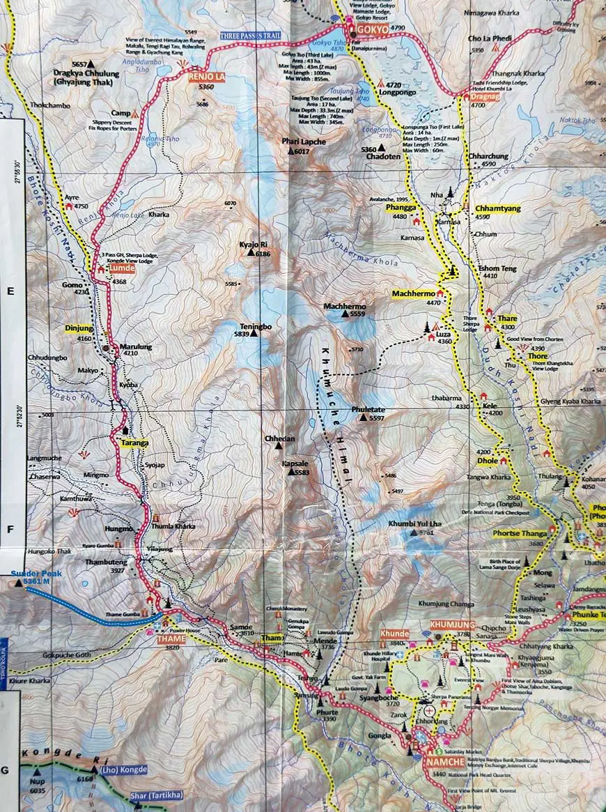
If you are staying in Thame village during your Renjo La Pass trek, a great short side trip is a hike to Sunder Peak. This peaceful viewpoint is not far from the village and offers stunning mountain views. It is perfect for trekkers who want to explore more without adding a full extra day to the itinerary. See the map below to understand the route to Sunder Peak in detail. The highlighted trail will help you plan your hike and know what to expect along the way.
Sunder Peak is not a high-altitude summit like other major peaks in the Everest region, but it is known for its incredible scenery. From the top, you can enjoy wide views of the Himalayas, including peaks like Thamserku, Kusum Kangaru, and parts of Cho Oyu. The peak offers a quiet and relaxing space, perfect for reflection, photography, and a peaceful break from the main trail.One of the best things about Sunder Peak is that it is very easy to reach from Thame village. The round-trip hike takes around 2 to 3 hours. The trail is gradual, with no technical sections, making it a good choice for trekkers of all ages and experience levels. It is also an excellent way to help with acclimatization before crossing the challenging Renjo La Pass. The best time to hike to Sunder Peak is early in the morning or late in the afternoon. These times offer the clearest skies and the best light for photos. You may want to carry some basic items with you, like water, snacks, a warm jacket, and a camera. Trekking poles are optional but can be helpful on the descent. Many trekkers skip Sunder Peak because it is not well-known. But that is what makes it special. It is quiet, beautiful, and uncrowded. If you want to enjoy a calm place with amazing mountain views, Sunder Peak is a perfect side trip. It adds extra beauty and meaning to your journey through the Khumbu region, making your Renjo La Pass trek even more unforgettable. |
The Renjo La Pass trek is classified as challenging, requiring good physical fitness and prior high-altitude experience. The route takes 14 to 18 days depending on itinerary variations, with daily hiking durations of 5 to 8 hours and significant altitude gains.
Day | Route Segment | Altitude (m) | Duration | Key Features |
1 | 2,846m → 2,610m | 3-4 hours | Gentle descent through Dudh Koshi Valley | |
2 | 2,610m → 3,440m | 6-7 hours | Steep climb, Hillary Suspension Bridge crossings | |
3 | Acclimatization in Namche | 3,440m | Rest day | Hike to Everest View Hotel (3,880m) |
4 | Namche to Dole | 3,440m → 4,110m | 5-6 hours | Ascend through rhododendron forests |
5 | Dole to Machhermo | 4,110m → 4,470m | 4-5 hours | Gradual climb, views of Cho Oyu (8,188m) |
6 | Machhermo to Gokyo | 4,470m → 4,790m | 5-6 hours | Pass Ngozumpa Glacier, reach Gokyo Lakes |
7 | Gokyo Ri Ascent | 4,790m → 5,357m | 3-4 hours (round trip) | Panoramic views of Everest, Lhotse, Makalu |
8 | Gokyo to Renjo La Pass → Lungden | 4,790m → 5,360m → 4,380m | 7-8 hours | Steep scree slopes, high-altitude exposure |
9 | Lungden to Namche (via Thame) | 4,380m → 3,440m | 6-7 hours | Descent through Sherpa villages |
10-11 | Return to Lukla | 3,440m → 2,846m | 2 days | Via Namche and Phakding |
This trek is physically tough but doesn’t require special climbing skills. The combination of thin air, long days, and variable conditions makes preparation essential.
Category | Specific Challenge | Details |
Altitude | Maximum elevation | 5,360m at Renjo La Pass |
Sleeping altitudes | Consistently above 3,500m after Namche | |
Highest overnight stop | Gokyo (4,790m) | |
Acclimatization needs | Mandatory rest days in Namche & Gokyo | |
Terrain | Pass day elevation change | 1,000m ascent / 1,500m descent in single day |
Surface conditions | - Loose scree near summit - Glacial moraines (Ngozumpa Glacier) | |
Trail consistency | Uneven footing throughout route | |
Weather | Optimal seasons | March-May & Sept-Nov (stable conditions) |
Winter challenges (Dec-Feb) | -15°C nights, icy trails requiring microspikes | |
Monsoon risks (Jun-Aug) | Landslides and obscured views | |
Additional | Navigation | Unmarked sections above Gokyo |
Challenges | Wind exposure | Strong gusts at high points |
Recommended gear | Trekking poles essential, microspikes for winter | |
Requirements | Physical fitness | 6-8 hour hiking days with packed gear |
Equipment | Cold-weather and altitude-specific gear | |
Experience | Prior high-altitude trekking strongly advised |
The Renjo La Pass trek helps you familiarise yourself with Sherpa culture, which is largely shaped by Tibetan Buddhism and adapted to the high-altitude environment. Villages along the route, including Namche Bazaar, Thame and Gokyo, maintain traditional lifestyles while accommodating modern trekking infrastructure.
Key monasteries like Thame Gompa (established in the 17th century) and Tengboche Monastery host seasonal festivals like Mani Rimdu, featuring masked dances.
Traditional Sherpa architecture features stone houses with carved wooden windows and sloped roofs to withstand heavy snow. Teahouses blend these designs with modern amenities, using solar panels for electricity. In remote areas like Lungden, buildings rely on yak dung for fuel and insulation.
Local Cuisine combines Tibetan influences with high-calorie needs. The staple dal bhat (lentil soup with rice) will give you sustained energy, while tsampa (roasted barley flour) is a portable Sherpa staple. Yak-based dishes like yak steak and yak butter tea are common, with the latter aiding hydration at altitude.
Teahouse Menus cater to trekkers with carb-heavy options:
Cultural etiquette you should be aware of while on this trek are respecting religious sites (walking clockwise around stupas) and asking permission before photographing people. The Saturday market in Namche showcases Tibetan trade goods, while Thame’s weekly market shows traditional economies.
The Renjo La Pass trek moves through Sagarmatha National Park, with diverse Himalayan flora and fauna across different altitude zones. The park’s protected ecosystem supports specialized species adapted to high-altitude conditions.
From Lukla to Renjo La , vegetation changes with altitude. The lower forests (2,800-3,500m) feature blue pine, Himalayan fir, and rhododendron blooms in spring. Between 3,500-4,500m, dwarf juniper and alpine shrubs dominate, with hardy edelweiss and gentians in summer. Above 4,500m, only lichen, mosses, and cushion plants survive the harsh conditions.
Himalayan tahr are frequently seen on cliffs near Gokyo and Thame. Smaller mammals include marmots (in high meadows) and pikas (rocky slopes). Rare sightings occur of musk deer in forested areas, and even rarer red pandas in the lower bamboo zones. The park maintains a healthy Himalayan black bear population below 3,500m, though they avoid human contact.
The region boasts over 200 bird species. Colorful Himalayan monal (Nepal's national bird) and blood pheasants forage in scrublands. Large raptors like the lammergeier (bearded vulture) and Himalayan griffon soar above passes. Snow pigeons and yellow-billed choughs are common at higher elevations.
All wildlife is protected within Sagarmatha National Park (UNESCO World Heritage Site). Strict regulations prohibit the hunting of endangered species like snow leopards,the collection of firewood (replaced by kerosene/yak dung) and off-trail hiking in sensitive alpine zones.
Trek Me Nepal Archives
Check out recent travel trends and news by Trek me Nepal


More Reasons Why Travellers Trust Us


 : Location, Altitude, Climate, Tengboche Monastery, Mani Rimbu, Accomodation & Scenic Highlights")


Bipin Thapa
Operation Manager | Official Trekking Guide
Anyone who has trekked before knows trekking requires planning, and a deep understanding of the land. That is where Bipin Thapa Magar comes in. As the Operations Manager at Trek Me Nepal, he is the ba... Read More