


Who We Are
Guide of the Year
Documents
Charity & SR
Latest Posts
Questions & Answers

The Gokyo Lakes are a series of six freshwater lakes located in Nepal's Sagarmatha National Park, within the Khumbu region of the Himalayas. Situated at high altitudes between 4,700 to 5,000 meters, these lakes are among the world's highest freshwater systems.
Formed by glacial meltwater from the Ngozumpa Glacier, the largest glacier in Nepal, the lakes are known for their striking turquoise and emerald colors, which vary with seasons and light conditions.
The lakes hold significant religious importance for both Hindus and Buddhists. Gokyo Tsho (Dudh Pokhari), the main lake, is particularly sacred, with rituals performed during the Janai Purnima festival.
As an offbeat trekking destination, the area offers a less crowded alternative to the Everest Base Camp trek, with panoramic views of peaks like Everest, Lhotse, and Cho Oyu.
Designated as both a UNESCO World Heritage Site and a Ramsar wetland, the Gokyo Lakes are recognized for their ecological importance. However, they face environmental threats from climate change, including glacial retreat and changing water levels.
The combination of natural beauty, cultural significance, and trekking opportunities makes this a unique destination in the Everest region.
Gokyo Lakes : Key Information at a Glance
| Feature | Details |
| Location | Khumbu region, Sagarmatha National Park, Nepal |
| Elevation | 4,700–5,000 meters |
| Total Lakes | 6 main glacial lakes |
| Formation | Meltwater from Ngozumpa Glacier (Nepal’s largest, 36 km long) |
| UNESCO/Ramsar Site | Yes (World Heritage & Ramsar wetland) |
| Religious Value | Gokyo Tsho sacred to Hindus & Buddhists; Janai Purnima rituals |
| Access Route | Trek from Lukla via Namche, Dole, Machhermo |
| Best Viewpoint | Gokyo Ri (5,357 m), views of Everest, Cho Oyu, Gyachung Kang |
| Environmental Issues | Glacial retreat (~20m/year), climate change impacts |
| Ecological Traits | Oligotrophic, frozen in winter, rare alpine species |
| Lake Highlights |
|
The Gokyo Lakes are located in the Khumbu region of northeastern Nepal, within Sagarmatha National Park (a UNESCO World Heritage Site). The lakes lie at coordinates 27°58′N to 28°00′N latitude and 86°40′E to 86°45′E longitude, approximately 30km west of Everest Base Camp.
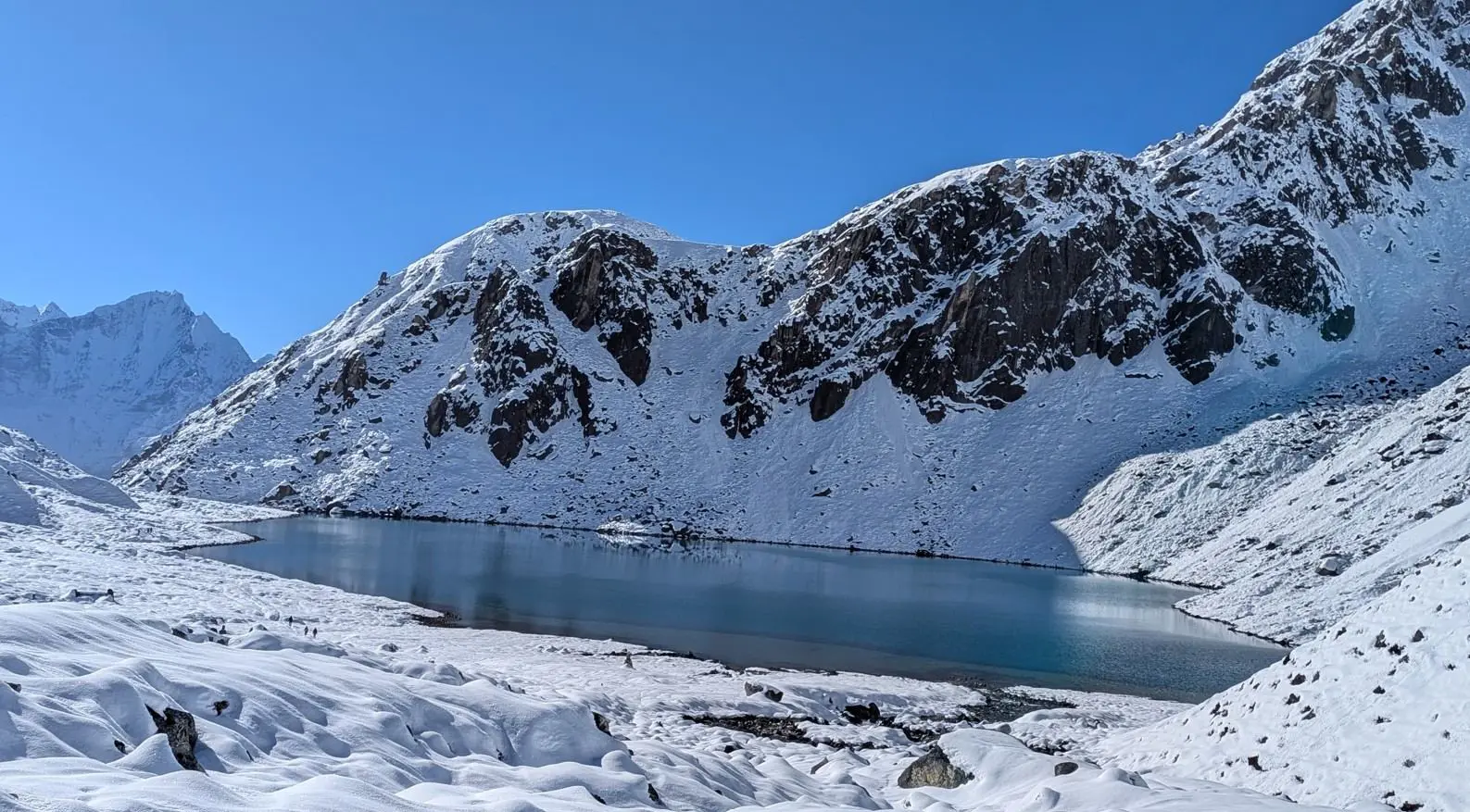
Situated at elevations between 4,700 to 5,000 meters, the lakes are fed by meltwater from the Ngozumpa Glacier, Nepal's largest glacier, which stretches 36km in length. The glacier's moraine forms natural dams that create the six main lakes.
The entire lake system covers an area of approximately 196 hectares within the Dudh Koshi river basin. The region features alpine tundra vegetation and is surrounded by Himalayan peaks including Cho Oyu (8,188m), Gyachung Kang (7,952m), and Everest (8,848m) visible from viewpoints like Gokyo Ri (5,357m).
Geologically, the area consists of metamorphic rocks (schists and gneisses) with glacial deposits. The lakes are oligotrophic (nutrient-poor) and freeze completely during winter months (December-February). As part of the Koshi River basin, they ultimately drain into the Ganges River system.
The Sagarmatha National Park protects this fragile ecosystem, which faces threats from glacial retreat (averaging 20m/year in some sections) and climate change impacts on water levels. Access is via the Gokyo Valley trekking route from Lukla, passing through Namche Bazaar, Dole and Machhermo villages.
| Lake Name | Elevation (m) | Size (ha) | Key Features | Cultural Significance | Ecological Notes |
| Gokyo Tsho (Dudh Pokhari) | 4,750 | 42 |
|
|
|
| Thonak Tsho | 4,870 | - |
|
|
|
| Taujung Tsho | 4,810 | 18 |
|
|
|
| Ngozumpa Tsho | 4,790 | - |
| - |
|
| Gyazumpa Tsho | 4,830 | 8 |
| - |
|
| Longpanga Tsho | 4,690 | 10 |
| - |
|
The Gokyo Lakes system consists of six principal glacial lakes in Sagarmatha National Park, with distinct geological, ecological and cultural characteristics. These lakes represent one of the world's highest freshwater ecosystems.
From the sacred Gokyo Tsho to the deep Thonak Tsho, each lake has unique hydrological properties (depth, water sources, seasonal variations), mineral compositions affecting water color and clarity, ecological communities of specialized alpine species, cultural significance in Sherpa and Buddhist traditions, and climate change vulnerability as glacial-fed systems.
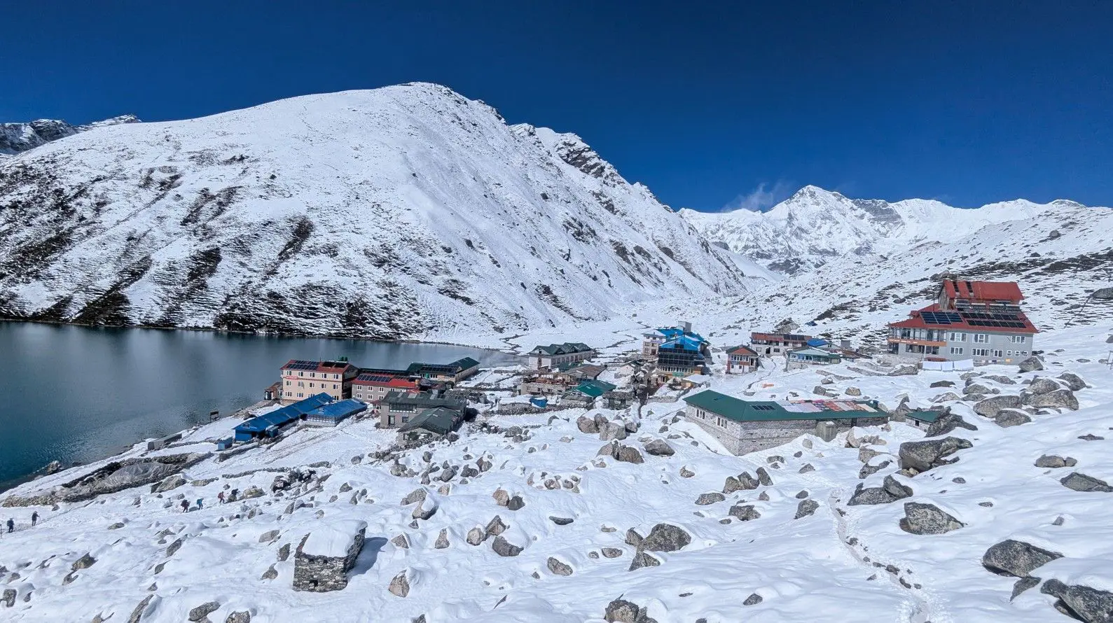
At 4,750 meters elevation, Gokyo Tsho is the largest and most significant of the Gokyo Lakes, covering approximately 42 hectares. This sacred lake serves as the religious center of the area, revered by both Hindus and Buddhists as the abode of Nagas (serpent deities).
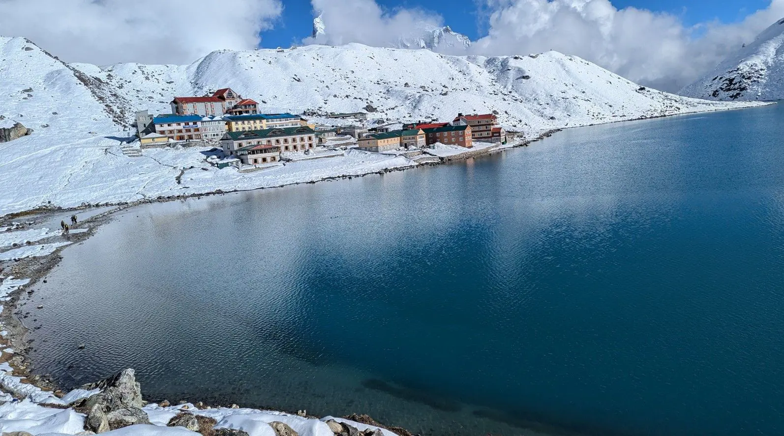
During the Janai Purnima festival, hundreds of pilgrims gather here for ritual baths and offerings. The lake's crystal-clear turquoise waters perfectly reflect surrounding peaks including Cho Oyu and Gyachung Kang. The shoreline features numerous Buddhist stupas, prayer flags, and stone cairns built by trekkers.
Scientific studies show the lake has exceptionally pure water with visibility exceeding 15 meters in dry seasons.
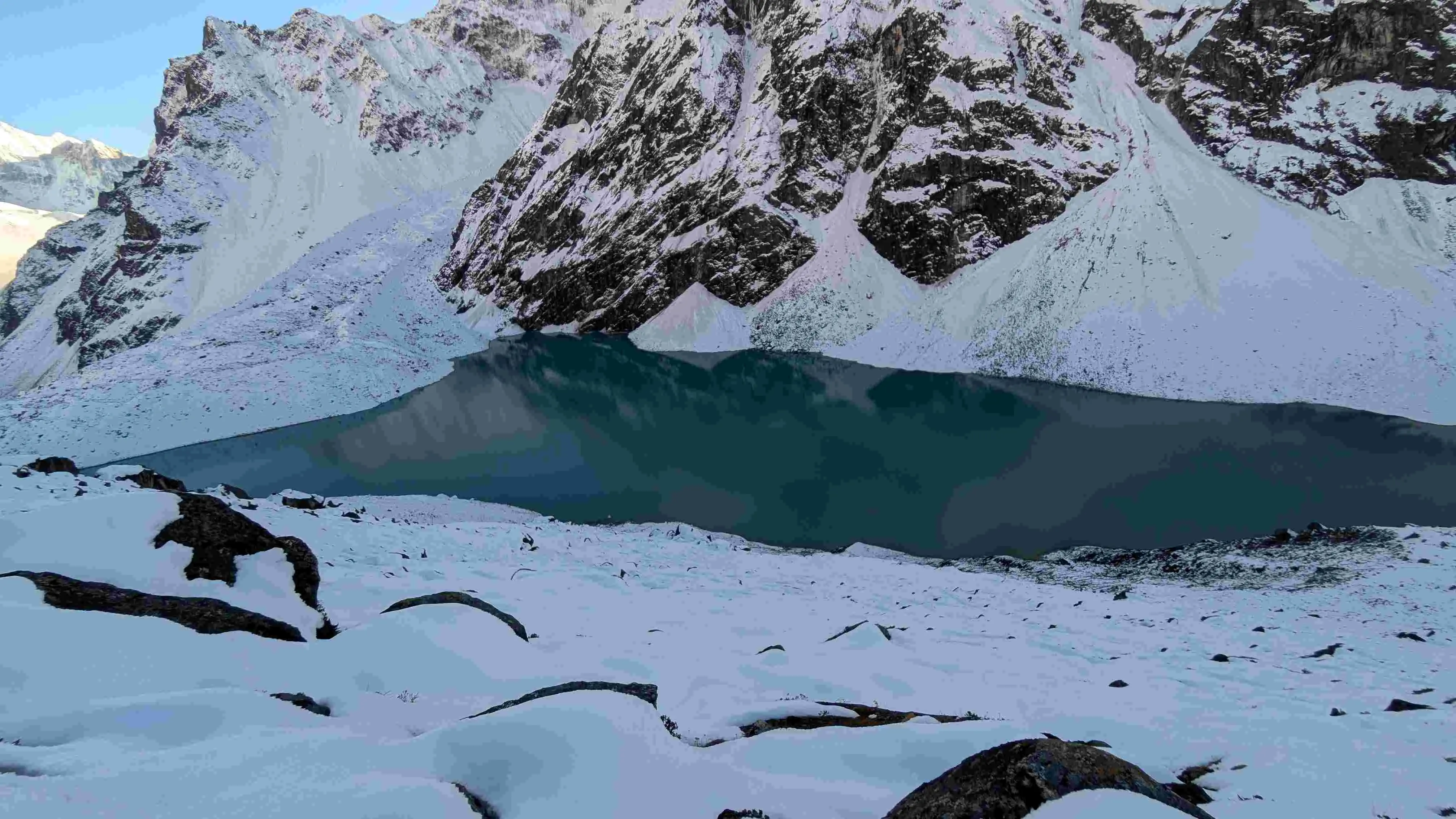
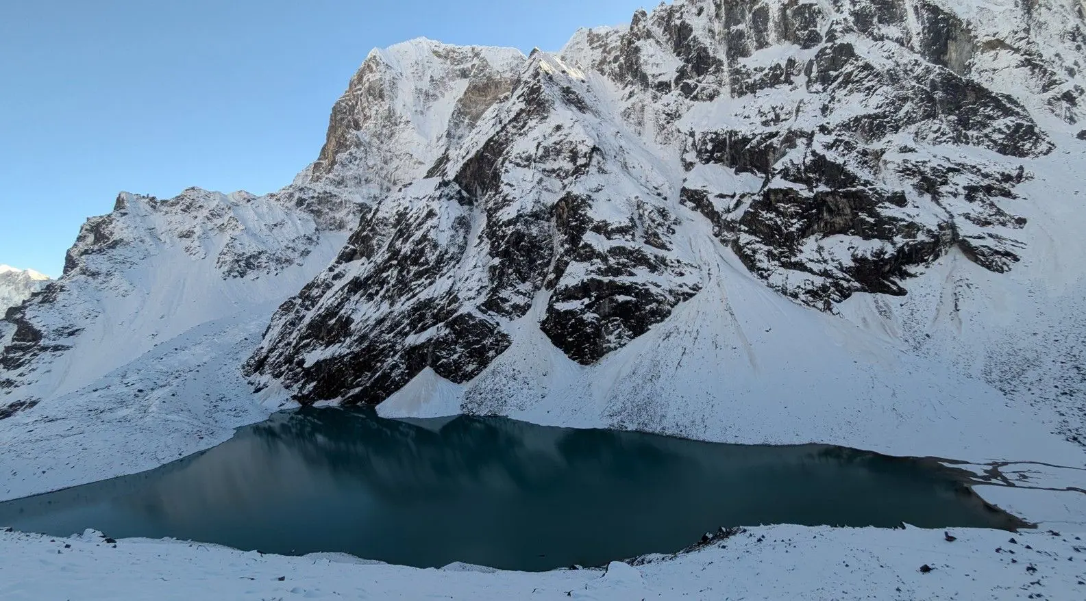
The deepest lake in the system at 4,870 meters, Thonak Tsho plunges to over 40 meters in its central basin. Recent bathymetric surveys revealed underwater cliffs and distinct thermal layers in its waters. While less visited for religious purposes, local Sherpa communities consider it home to protective spirits.
The lake's dark indigo color results from its depth and the mineral-rich glacial runoff that feeds it. During winter, it develops thick ice cover up to 2 meters thick, while summer brings floating icebergs calved from the adjacent Ngozumpa Glacier.
Scientists monitor this lake closely as an indicator of climate change impacts in high-altitude ecosystems.
Situated at 4,810 meters, Taujung Tsho spans 18 hectares and displays remarkable seasonal color variations, from emerald green in monsoon to deep cobalt in winter. Hydrological studies show it has the most stable water levels among the Gokyo Lakes due to subsurface springs.
The lake's eastern shore features extensive wetlands that support rare Himalayan bird species including the Ibisbill and Snow Partridge. Geologists have identified unusual mineral deposits along its northern banks, creating natural terraces that change color throughout the day.
While not a major pilgrimage site, local herders perform annual blessing ceremonies here for their livestock.
Closest to the Ngozumpa Glacier at 4,790 meters, this lake serves as the primary glacial meltwater collector for the system. Its milky turquoise waters contain high concentrations of rock flour (glacial silt), reducing visibility to just 1-2 meters. The lake's size fluctuates dramatically.
Researchers have documented subglacial channels feeding the lake, which occasionally produce sudden water level surges. Despite its harsh environment, the lake margins support hardy alpine mosses and crustose lichens.
At 4,830 meters, Gyazumpa Tsho covers 8 hectares and is renowned for its mirror-like surface reflections. Unlike other lakes in the system, it maintains near-constant water levels year-round due to a unique subsurface drainage system. The lake's circular shape and steep basin walls suggest it may occupy a glacial cirque formed during the last ice age.
During summer mornings, the lake often displays an optical phenomenon called sun dogs caused by ice crystals in the atmosphere. Local guides report spotting Himalayan snow trout in its shallows during warm months.
The lowest at 4,690 meters, Longpanga Tsho covers 10 hectares and features the most diverse shoreline vegetation of all the lakes. Aquatic surveys have identified 12 species of diatoms and alpine phytoplankton unique to this lake. Its waters transition from deep blue at the center to greenish hues near the shores due to microbial mats.
The lake receives substantial input from seasonal snowmelt streams, creating delta formations along its eastern edge. Paleolimnological studies of sediment cores reveal this lake has existed for at least 3,000 years, making it the oldest in the system. During autumn, the surrounding slopes turn golden with dwarf rhododendrons and alpine grasses.
The Gokyo Lakes hold deep spiritual meaning in both Hinduism and Tibetan Buddhism. For Hindus, these lakes are considered manifestations of Lord Shiva’s tears, with Gokyo Tsho (Dudh Pokhari) being the most sacred.
During the annual Janai Purnima festival (typically in August), pilgrims perform ritual baths there. Brahmin priests conduct special ceremonies where sacred threads (janai) are changed, and offerings of rice, flowers and coins are made to the lake deities on the day.
Buddhist traditions associate the lakes with Dorje Phagmo, the female embodiment of wisdom. Local Sherpa communities believe the lakes are protected by Lu (naga spirits) who control water sources and weather.
Numerous Mani walls (stone tablets carved with prayers) and prayer flags surround the lakes, with the largest concentration near Gokyo Tsho. Monks from Thame Monastery perform annual blessing ceremonies to maintain spiritual harmony.
The lakes feature prominently in Sherpa oral history, with legends claiming Guru Rinpoche (Padmasambhava) meditated here in the 8th century. Strict cultural taboos prohibit washing clothes in the lakes and taking stones or plants from the shoreline.
The Gokyo Lakes system was designated a Ramsar Wetland of International Importance in 2007 (Site No. 1692) due to its unique high-altitude wetland ecosystem, role as habitat for migratory birds, geological importance as glacial-fed lakes and cultural significance to indigenous communities (Ramsar Sites Information Service, 2007).
As part of Sagarmatha National Park, the lakes receive multiple legal protections under National Parks and Wildlife Conservation Act 1973, Buffer Zone Management Regulations and Ramsar Convention guidelines.
Climate Change Impacts
The Gokyo Lakes face severe threats from global warming, with measurable impacts on the region's fragile ecosystem. The Ngozumpa Glacier, which feeds the lakes, has retreated about 1.5 km since 1960, altering water flow patterns.
Due to accelerated glacial melt, lake volumes have expanded by significantly since the 1950s, increasing the risk of Glacial Lake Outburst Floods (GLOFs). Scientific data reveals a steady 0.5°C increase in water temperature per decade, disrupting aquatic life.
Additionally, ice melt now occurs 2 to 3 weeks earlier than in the 1980s, shortening the frozen period critical for local biodiversity.
Tourism Pressures
The growing popularity of the Gokyo Lakes trek brings environmental strain. With over 5,000 visitors annually, waste management has become a major challenge, particularly non-biodegradable trash.
Fuelwood consumption by teahouses threatens nearby juniper shrubs, a key high-altitude species. Unregulated foot traffic has also led to trail erosion, damaging fragile alpine vegetation and destabilizing slopes.
Local Sherpa communities participate in conservation through annual clean-up campaigns before monsoon season, sacred site guardians program training locals in visitor management and ecotourism initiatives that direct funds to conservation projects.
The lakes remain an important case study for climate change adaptation in high-altitude wetlands, with ongoing research by organizations like ICIMOD (International Centre for Integrated Mountain Development), Department of Hydrology and Meteorology Nepal and Sagarmatha Pollution Control Committee.
The Gokyo Lakes trek follows the western sector of Nepal's Khumbu region, an alternative to the classic Everest Base Camp trail. This route focuses on three key areas: Dole (4,038m), Machhermo (4,470m), and Gokyo (4,790m).
Unlike the more crowded EBC path, this trail provides trekkers with access to the Ngozumpa Glacier (Nepal's longest glacier) and the sacred Gokyo Lakes, while maintaining relatively lower foot traffic.
The western Khumbu's terrain transitions dramatically from rhododendron forests near Namche to stark alpine landscapes above Machhermo.
The Gokyo Lakes and Everest Base Camp (EBC) trek offered by Trek Me Nepal typically spans 12–14 days, combining high-altitude passes, glacial lakes, and iconic Himalayan vistas. We offer two primary routes:
1) Gokyo Lakes Trek (13 Days): Focuses on the Gokyo Valley, including Gokyo Ri and the Ngozumpa Glacier.
2) Gokyo-Chola Pass-EBC Circuit (14 Days): Extends to Everest Base Camp via Cho La Pass , with a helicopter return from Gorakshep.
Both itineraries begin with a flight from Kathmandu to Lukla, followed by trekking through Sagarmatha National Park.
| Category | Gokyo Lakes Trek | Gokyo-EBC Circuit |
| Duration | 13 days | 14 days |
| Max Altitude | 5,357m (Gokyo Ri) | 5,545m (Kala Patthar) |
| Difficulty | Challenging | Strenuous |
| Total Walking | ~80–90 km | ~100–110 km |
| Acclimatization | 2 rest days | 3 rest days |
Dole-Machhermo-Namche Bazaar Section
This critical segment forms the backbone of the trek's acclimatization strategy:
Dole (4,038m): Serving as the transition point between the forested middle hills and high alpine zones, Dole marks where the landscape shifts dramatically. The village sits amidst summer grazing pastures (kharkas) and offers the first clear views of Cho Oyu (8,188m). Trekkers typically notice thinner air here, prompting the body's initial high-altitude adjustments.
Machhermo (4,470m): The last substantial settlement before Gokyo, Machhermo features an HRA (Himalayan Rescue Association) medical post specializing in altitude sickness treatment. The village's stone-walled lodges cluster beside the Dudh Koshi River, with the Ngozumpa Glacier visible upstream. This stop provides critical pre-Gokyo acclimatization.
Namche Bazaar (3,440m): The trek's logistical and cultural hub, Namche combines modern amenities (ATMs, pharmacies, gear shops) with traditional Sherpa architecture. Its bowl-shaped location demands a steep ascent that naturally enforces acclimatization.
The village's Saturday market remains an important regional trading event, where Tibetan goods exchange hands alongside trekking supplies. Namche's elevation makes it ideal for physiological adaptation before ascending higher.
| Day | Altitude (m) | Route Segment | Key Stops & Highlights | Trekking Time | Accommodation |
| 1 | 1,350 | Arrival in Kathmandu | Airport transfer, briefing, gear check | - | Hotel |
| 2 | 2,610 | Fly to Lukla → Phakding | Scenic flight, Dudh Koshi River crossings | 3-4 hrs | Teahouse |
| 3 | 3,440 | Phakding → Namche Bazaar | Hillary Bridge, Sagarmatha National Park entry | 6-7 hrs | Teahouse |
| 4 | 3,440 | Acclimatization at Namche Bazaar | Hike to Everest View Hotel, Sherpa Museum | 3-4 hrs | Teahouse |
| 5 | 4,038 | Namche → Dole | Rhododendron forests, Thamserku views | 6-7 hrs | Teahouse |
| 6 | 4,470 | Dole → Machhermo | Alpine meadows, first views of Cho Oyu | 4-5 hrs | Teahouse |
| 7 | 4,790 | Machhermo → Gokyo | Ngozumpa Glacier, arrival at Gokyo Lakes | 5-6 hrs | Teahouse |
| 8 | 5,357 | Gokyo Ri Summit | Panorama of Everest/Lhotse/Makalu/Cho Oyu | 4-5 hrs RT | Teahouse |
| 9 | 4,038 | Gokyo → Dole | Return via Machhermo | 6-7 hrs | Teahouse |
| 10 | 3,440 | Dole → Namche Bazaar | Re-entry to Namche's markets | 5-6 hrs | Teahouse |
| 11 | 2,610 | Namche → Phakding | Descend through pine forests | 6-7 hrs | Teahouse |
| 12 | 2,860 | Phakding → Lukla | Final Dudh Koshi crossings | 3-4 hrs | Teahouse |
| 13 | 1,350 | Fly to Kathmandu | Morning flight, farewell dinner | - | Hotel |
| Day | Altitude (m) | Route Segment | Key Stops & Highlights |
| 1-7 | Same as above | Same as Gokyo Lakes trek | Includes Dole, Machhermo, Namche Bazaar |
| 8 | 5,357 | Gokyo Ri Summit | - |
| 9 | 4,790 → 4,700 | Gokyo → Thangnak | Ngozumpa Glacier traverse |
| 10 | 4,700 → 5,420 → 4,830 | Thangnak → Cho La Pass → Dzongla | High-altitude pass crossing |
| 11 | 4,830 → 4,940 → 5,164 | Dzongla → Lobuche → Gorakshep | Approach to EBC |
| 12 | 5,545 → Kathmandu | Kala Patthar → Heli return | EBC visit, helicopter flight |
| 13 | 1,350 | Kathmandu sightseeing | Cultural tours |
| 14 | - | Departure | - |
At 5,357 meters, Gokyo Ri is the most accessible and rewarding viewpoint in the Gokyo Valley, with unobstructed views of the Gokyo Lakes and the Himalayan range. The ascent begins from Gokyo village and takes 2 to 3 hours along a well-maintained trail with an average gradient of 30 to 35 degrees.
The hike involves 600 meters of elevation gain over 2.5 kilometers, with the final section being the steepest. The summit has a 360-degree panorama, making it comparable to Kala Patthar for viewing multiple 8,000-meter peaks simultaneously. Additionally, Gokyo Ri Summit sees less footfall than Kala Patthar, making it quieter and more enjoyable for its visitors.
From the summit, four of the world’s 14 highest peaks are clearly visible.
| Peak Name | Elevation (m) | Distance from Summit | Direction | Notable Features |
| Mount Everest | 8,848 | 20 km | Northeast | Central peak of Himalayan range |
| Lhotse | 8,516 | Adjacent to Everest | Northeast | Forms the Lhotse Wall with Everest |
| Makalu | 8,485 | 40 km | East-southeast | Distinctive sharp pyramid shape |
| Cho Oyu | 8,188 | 15 km | Northwest | Broad, snow-covered slopes |
Additional notable peaks include:
Optimal Viewing Conditions
Photography Recommendations
When planning a Himalayan trek in Nepal's Khumbu region, travelers often deliberate between the Gokyo Lakes trek and the classic Everest Base Camp (EBC) route.
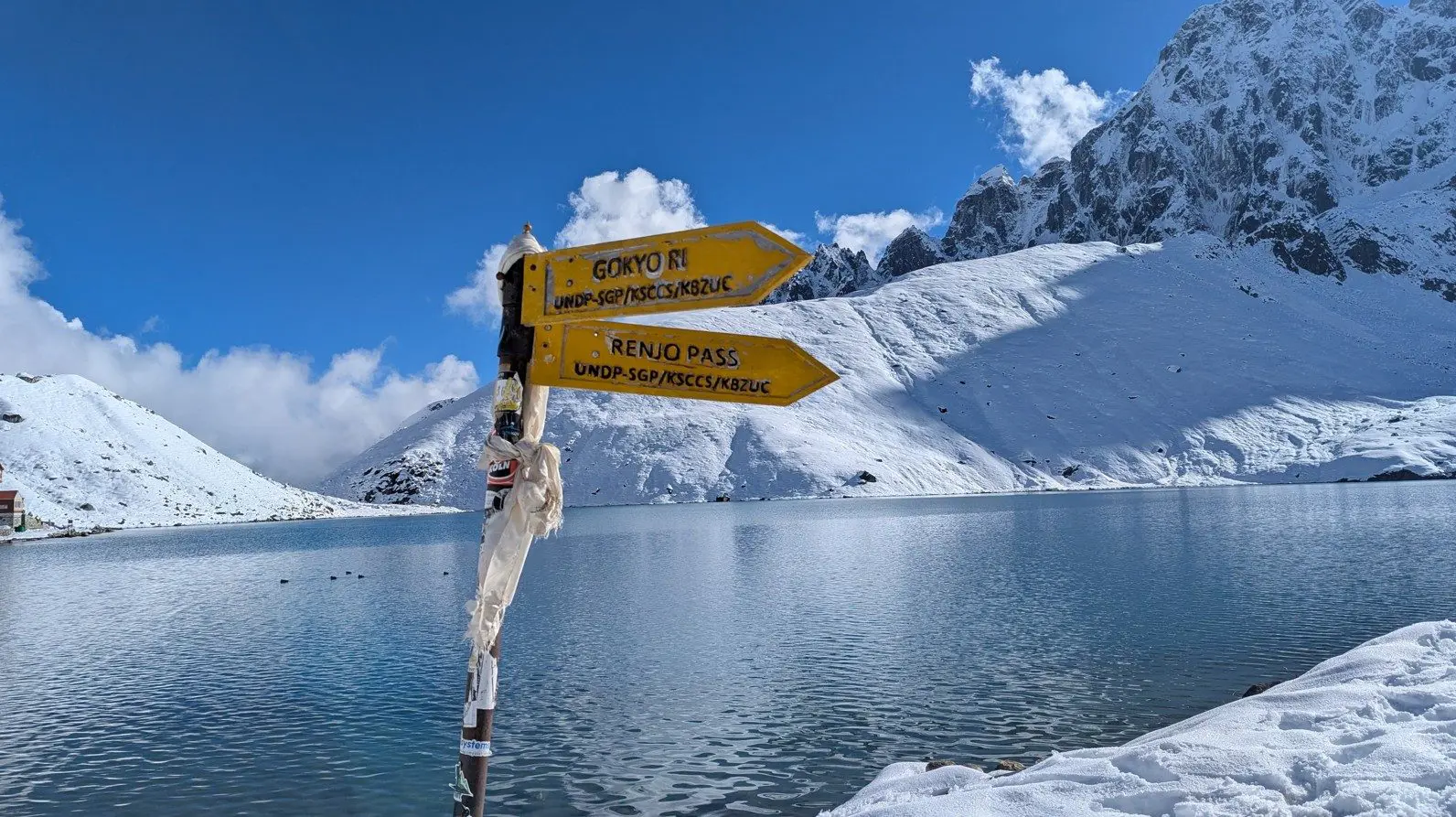
Both treks have the same starting point in Lukla and pass through Sagarmatha National Park, but diverge after Namche Bazaar .
The Gokyo route veers west into the glacier-carved valley containing the sacred lakes, while the EBC trail continues north along the traditional Everest approach.
| Category | Gokyo Lakes Trek | Everest Base Camp (EBC) Trek | Combined Gokyo-Chola-EBC Circuit |
| Primary Focus | Glacial lakes & Renjo La Pass | Everest Base Camp & Kala Patthar | Complete Khumbu experience |
| Key Highlights |
|
|
|
| Max Altitude | 5,360m (Renjo La Pass) | 5,545m (Kala Patthar) | 5,545m (Kala Patthar) |
| Daily Hiking | 5-6 hours | 6-7 hours | 6-8 hours |
| Trail Traffic | Low to moderate | High | Moderate |
| Scenery | Turquoise lakes, glacier views | Classic Everest vistas, glacial moraines | Combines both landscapes |
| Technical Difficulty | Moderate (steep climbs to viewpoints) | Moderate (rocky trails near EBC) | Challenging (pass crossing) |
| Cultural Experience | Remote Sherpa villages, lake rituals | Larger settlements, famous monasteries | Comprehensive cultural exposure |
| Teahouse Availability | Basic, fewer options | More developed, higher capacity | Mixed along route |
| Best For |
|
|
|
| Physical Demand | Moderate | Moderate to high | High |
| Best Season | March-May & Sept-Nov | Same as Gokyo | Same as Gokyo |
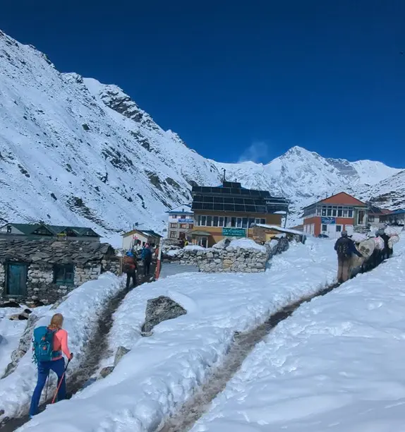
The Gokyo Lakes trek offers basic teahouse accommodation along the entire route, with facilities becoming more rudimentary at higher altitudes. In larger villages like Namche Bazaar, lodges provide comfortable rooms with basic amenities, while in higher elevation stops such as Gokyo, accommodations are simpler with shared facilities.
Most teahouses feature communal dining areas heated by wood stoves, which serve as social hubs for trekkers during evenings. Dining options follow a standard Nepali trekking menu, with meals designed to provide sufficient energy for high-altitude hiking.
The staple dal bhat (lentil curry with rice) remains the most reliable and nutritious option, typically served with vegetable sides. Other common dishes include noodle soups, fried rice, and basic Western-style breakfast items. As elevation increases, menu variety decreases and food preparation becomes simpler due to logistical challenges.
Food safety considerations become particularly important above Namche Bazaar. Most teahouses can accommodate vegetarian diets, while meat dishes become increasingly uncommon at higher elevations.
Trekkers should note that all supplies are either carried up by porters or yaks, which explains the limited variety and simple preparation methods at altitude.
This is an authentic way to experience Sherpa hospitality while supporting local communities. Most lodges are family-run operations that have adapted to cater to trekkers' basic needs while maintaining traditional mountain lifestyles. There is even cultural exchange between trekkers and local staff.
At the highest elevations near Gokyo Lakes, accommodations focus primarily on providing essential shelter and warmth rather than comfort. The limited infrastructure at these altitudes reflects the challenging environment and remote location of the trek.
Despite the simplicity, these high mountain lodges offer a unique opportunity to experience the Himalayan wilderness while having basic needs met.
The Gokyo Valley is part of Nepal's Khumbu region which is home to indigenous Sherpa communities. These high-altitude dwellers maintain a unique cultural identity with Tibetan Buddhism as well as mountain livelihood practices.
Villages along the route feature Buddhist monasteries, mani walls (stone tablets carved with prayers) and prayer flags marking sacred spaces. The Sherpa language, derived from Tibetan, remains widely spoken alongside Nepali.
Buddhist rituals are visible throughout the trek. Local monasteries like those in Namche Bazaar and Thame hold morning prayers open to visitors. The region's sacred geography includes the Gokyo Lakes, believed to be protected by nāga (water spirits).
Visitors may witness Mani Rimdu festival (October/November), daily prayer wheel rotations and butter lamp offerings at shrines.
Altitude Safety
The Gokyo Lakes trek reaches elevations exceeding 5,000 meters, making proper acclimatization essential. The recommended ascent rate is 300 to 400 meters per day once above 3,000 meters to reduce the risk of Acute Mountain Sickness (AMS).
Mandatory rest days in Namche Bazaar (3,440m) and Machhermo (4,470m) help trekkers adjust to the altitude.
Major AMS symptoms to monitor include persistent headache, nausea, dizziness, and loss of appetite. Severe cases may progress to HAPE (High Altitude Pulmonary Edema) or HACE (High Altitude Cerebral Edema), requiring immediate descent.
Trail Safety
Weather conditions in the Himalayas can change rapidly, with temperatures dropping below freezing even in warmer months. Trekkers should be prepared for sudden snowfall, strong winds, and low visibility. Some trail sections, particularly near glacial moraines, involve navigating loose rocks and uneven terrain.
Basic medical posts in Namche Bazaar and Pheriche provide emergency care, but carrying a personal first-aid kit is advisable. Proper footwear with ankle support is crucial for stability on rocky paths.
Cultural Etiquette
Respecting local customs is vital when trekking through Sherpa communities. Always walk clockwise around religious structures such as stupas, mani walls, and prayer wheels, as this aligns with Buddhist tradition. Before photographing people, monasteries, or religious ceremonies, always ask for permission.
When entering monasteries or homes, remove your shoes as a sign of respect. Avoid touching or pointing at religious artifacts with your feet, which is considered disrespectful.
Emergency Preparedness
The weather in Gokyo varies dramatically with the seasons, from bone-chilling winters to rain-soaked summers and crisp, clear autumns. Trekkers should come well-prepared for sub-zero temperatures year-round, especially at night.
Autumn (September to November) is widely considered the best time to visit Gokyo, thanks to its stable weather, minimal rainfall, and breathtaking mountain views. Spring (March to May) is also a great time, with blooming alpine flora and moderate temperatures.
Summer (June to August) brings the monsoon, so while the trails are greener and quieter, expect cloud cover and heavy rain. Winter (December to February) offers clear skies but is best left to experienced trekkers due to extreme cold and snow.
Pro tip: Always pack layers, a proper down jacket, and waterproof gear no matter when you go. Nights are cold even in summer, and sudden weather changes are common in high altitude.
| Season | Avg. Precipitation (mm) | Avg. Warmest Temp (°C) | Avg. Coldest Temp (°C) | Avg. Daily Max (°C) | Avg. Daily Min (°C) |
| Spring | 67 mm | 8°C | -11.7°C | 3.7°C | -6.3°C |
| Summer | 343 mm | 12.7°C | 2°C | 10°C | 4.7°C |
| Autumn | 86 mm | 8.7°C | -7.3°C | 6°C | -2.7°C |
| Winter | 18 mm | 3°C | -20.7°C | -2.3°C | -14.3°C |
Note: (Meteoblue, 2025)
| Month | Precipitation (mm) | Warmest Day Temp (°C) | Coldest Night Temp (°C) | Mean Daily Max (°C) | Mean Daily Min (°C) |
| March | 31 mm | 5°C | -18°C | 0°C | -12°C |
| April | 55 mm | 8°C | -11°C | 4°C | -6°C |
| May | 115 mm | 11°C | -6°C | 7°C | -1°C |
Note: (Meteoblue, 2025)
Spring in Gokyo (March to May) brings gradually warming temperatures and increasing precipitation. March still feels like winter, with frigid nights dropping as low as -18°C and average daytime highs hovering around 0°C. April sees a slight thaw, with warmer afternoons reaching 8°C and nights becoming somewhat milder at -11°C.
By May, the landscape begins to bloom under warmer temperatures, with daytime highs climbing to 11°C and nights rarely falling below -6°C. However, May also marks the onset of heavier precipitation, with rainfall rising to 115 mm.
Overall, spring is a transitional season in Gokyo, perfect for trekkers seeking crisp mountain air, snow-dusted trails, and quieter routes before the summer crowds arrive.
| Month | Precipitation (mm) | Warmest Day Temp (°C) | Coldest Night Temp (°C) | Mean Daily Max (°C) | Mean Daily Min (°C) |
| June | 231 mm | 12°C | 0°C | 10°C | 4°C |
| July | 451 mm | 13°C | 3°C | 10°C | 5°C |
| August | 346 mm | 13°C | 3°C | 10°C | 5°C |
Note: (Meteoblue, 2025)
Summer in Gokyo (June to August) is the warmest and wettest time of the year, dominated by the monsoon season. Daytime temperatures peak at around 12–13°C, offering relatively mild warmth compared to lower altitudes. Nights are no longer freezing, with lows ranging from 0°C in June to around 3°C in July and August.
However, the increased warmth comes with significant rainfall, June sees over 230 mm of precipitation, which surges to a peak of 451 mm in July before tapering slightly to 346 mm in August.
The trails can be muddy and cloud cover frequent, limiting mountain views. Still, the lush alpine scenery and fewer trekkers can make it a rewarding time for those seeking solitude and a different Himalayan experience.
| Month | Precipitation (mm) | Warmest Day Temp (°C) | Coldest Night Temp (°C) | Mean Daily Max (°C) | Mean Daily Min (°C) |
| September | 199 mm | 11°C | -1°C | 9°C | 3°C |
| October | 50 mm | 9°C | -9°C | 6°C | -3°C |
| November | 9 mm | 6°C | -12°C | 3°C | -8°C |
Note: (Meteoblue, 2025)
Autumn (September to November) is one of the most popular trekking seasons in Gokyo, thanks to its clear skies and stable weather. September transitions from the monsoon with moderate rainfall (199 mm), relatively warm days at 11°C, and nights dipping just below freezing.
By October, precipitation drops significantly to 50 mm, skies clear up, and the landscape offers spectacular mountain views. However, temperatures start to drop, days peak at 9°C, and nights can fall to -9°C.
November brings crisp, dry conditions with only 9 mm of precipitation, daytime highs around 6°C, and frigid nights reaching -12°C.
The air is cold but clean, and visibility is at its best, making autumn ideal for high-altitude photography and peaceful trekking.
| Month | Precipitation (mm) | Warmest Day Temp (°C) | Coldest Night Temp (°C) | Mean Daily Max (°C) | Mean Daily Min (°C) |
| December | 12 mm | 5°C | -17°C | 0°C | -12°C |
| January | 18 mm | 2°C | -23°C | -4°C | -16°C |
| February | 25 mm | 2°C | -22°C | -3°C | -15°C |
Note: (Meteoblue, 2025)
Winter in Gokyo (December to February) is extremely cold, with heavy snow cover and sharply reduced temperatures. December starts with chilly days at 5°C and harsh nights dropping to -17°C, while precipitation remains low at just 12 mm.
January is the coldest month of the year, with daytime highs struggling to reach 2°C and bone-chilling nights plummeting to -23°C.
February remains equally cold, though slightly warmer, with average highs around -3°C and lows of -22°C. Despite the intense cold, the clear, blue skies and snow-blanketed landscapes create a dramatic, peaceful beauty.
However, trekking during this season is only recommended for experienced adventurers well-prepared for sub-zero conditions.
Why Choose Trek Me Nepal for Your Gokyo Trek
We are a licensed and certified trekking operator specializing in the Everest region, including the Gokyo Lakes and Cho La Pass routes. Our experienced local guides hold government licenses and extensive knowledge of high-altitude terrain.
They carry essential safety gear, including pulse oximeters and medical kits, ensuring proper acclimatization and emergency readiness.
Recognized as one of Nepal's top trekking agencies, we maintain a 1:4 guide-to-trekker ratio and enforce strict porter welfare policies. Our operations are backed by TAAN and the Nepal Tourism Board, with a proven track record of 5-star rated trips on platforms like TripAdvisor.
We prioritize sustainable trekking practices, including waste management protocols, solar-powered teahouse partnerships, and our ‘One Guest One Tree’ reforestation initiative. By booking with us, you support local Sherpa communities through fair wages and ethical tourism.
Ready to trek? Book today with Trek Me Nepal!
Meteoblue. (2025). Climate & weather data for Gokyo. Meteoblue. https://www.meteoblue.com/en/weather/historyclimate/climatemodelled/gokyo_nepal_7996798
Ramsar Sites Information Service. (2007). Gokyo and associated lakes. Ramsar Sites Information Service. https://rsis.ramsar.org/ris/1692
Trek Me Nepal Archives
Check out recent travel trends and news by Trek me Nepal


More Reasons Why Travellers Trust Us


 : Location, Altitude, Climate, Tengboche Monastery, Mani Rimbu, Accomodation & Scenic Highlights")


Bipin Thapa
Operation Manager | Official Trekking Guide
Anyone who has trekked before knows trekking requires planning, and a deep understanding of the land. That is where Bipin Thapa Magar comes in. As the Operations Manager at Trek Me Nepal, he is the ba... Read More